“What is the Risk that Surface Water will be Affected if a Deep Geological Repository for All of Canada’s High Level Nuclear Waste Proceeds?”
There are three primary ways that surface water could or will become contaminated as a result of creating and operating a deep geological repository (DGR) as proposed by the Nuclear Waste Management Organization (NWMO):
- entry into the surface water or near surface groundwater as a result of accidents during transportation
- during inspection / repackaging of the used fuel at the repository site
- migration of contaminated groundwater from the DGR to the surface
Additionally, if the NWMO were to proceed with their “optional” interim shallow caverns for storage of the used fuel at the site, or if there were accidents during the transfer of the used fuel from the transportation containers to the permanent containers or during transfer of the permanent containers to the emplacement rooms in the DGR, additional releases would be expected.
(1) Direct Entry into Surface Water
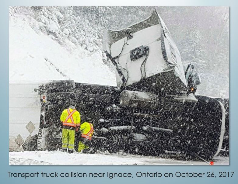
Collisions/Derailments During Transportation: The NWMO is planning to bury all of Canada’s highly radioactive nuclear fuel waste in a deep geological repository (DGR) approximately 500 metres below surface. This will mean transporting an estimated 100,000 tonnes of waste from as far away as New Brunswick to the selected site: two or three trucks per day travelling the TransCanada highway for 50 years. Transport truck crashes have increased at an alarming rate in Northern Ontario. Response times are long to crash sites. If one of these shipments was ruptured during a crash, radioactive material could enter the surface water via small lakes, rivers or even Lake Superior. Once introduced into the waterway, it would be irretrievable, with the potential for extremely devastating results.
(2) Contamination of Surface Water Onsite
(2a) Inspection / Repackaging on site:
While details of how the process will be conducted have not been released and the NWMO describes the current information about the Used Fuel Packaging Plant as “conceptual”, it is clear that spent fuel arriving on site in transportation containers will be repackaged in different containers for underground burial. It is expected that this will occur in a building on site, constructed specifically for this purpose. The NWMO has been vague about the length of time material might be stored at surface pending inspection and repackaging. Contaminated by-products of the hazardous repackaging process will need to be managed. Liquid wastes will be generated by underground sumps in the DGR but also from “decontaminating” processes in the Used Fuel Packaging Plant.
While not detailed, the NWMO’s plan to date is to use settling ponds to collect these liquid radioactive wastes and then release the water into a local waterbody.
The NWMO “conceptual” plan does not indicate any plan to monitor surface water for radionuclides, even at points of discharge into surrounding surface water.
The repackaging facility will be a permanent operation as long as spent fuel is being transported (minimum 45 years) and will create the potential for radioactive material to enter the surface water for as long as it is in operation and longer if the ground itself becomes contaminated.
(2b) Shallow Storage Pending Deep Burial:
The NWMO has also been vague about the possibility of temporarily storing high level nuclear waste in what they have called the “shallow storage option”. While they have not defined what this would look like, it has been referenced in each iteration of the DGR plan. Considering the logistics of building the DGR, transporting the material, inspecting and repackaging, it would not be surprising to see high-level nuclear waste stored at or near surface for long periods of time. This would also present an opportunity for contaminated material to enter the surface water flow directly. [Reference: See NWMO: March 2021 – Implementing Adaptive Phased Management 2021-2025 – page 40.]
(3) Migration of Contaminated Groundwater from a DGR to the Surface
The question of potential contamination of groundwater from a deep geological repository (DGR) is perhaps one of the greatest concerns and also one of the hardest to predict. The science of hydrogeology (the study of the occurrence, distribution, and movement of water below the Earth’s surface) is a relatively new field. This is due partly to the difficulty in measuring and studying it.
Furthermore, the challenge of modelling groundwater movement increases significantly with its depth below surface. Hydrogeologists make predictions based on the geology, integrity of rock formations and other factors specific to individual areas, but limited information means limited certainty regarding conclusions derived, which would need to be qualified.
Hydrogeological investigations have become an accepted requirement for proposals involving new building foundations, dam construction, aggregate extraction permits (gravel pits) and domestic/commercial waste disposal sites. All of these activities are concerned with relatively shallow depths below surface where groundwater is expected to be active and actual measurements are possible through wells drilled from surface.
In terms of deep hydrogeological study, the mining industry has done extensive work over the years. Mines have been developed at much greater depths than what is proposed by the NWMO. Water migrates via the path of least resistance to areas of lower pressure. Any underground cavern will offer an opportunity for groundwater to accumulate. Water that collects in operating mines has to be pumped back to the surface in order for work to continue safely. If a mine becomes inactive and pumping of water stops, the mine will gradually fill with water. This is because the area of least resistance would be upward once water has reached ‘rock bottom”.
The NWMO is proposing to create an underground cavern (DGR), fill it with canisters of spent fuel, seal it and walk away. Whether or not the containers will withstand the forces of heat, pressure and chemical reaction or how long it might take for them to fail is the subject of a separate discussion. It is generally agreed, however, that water will enter the DGR (in fact, the NWMO plan relies on water saturating the bentonite clay which the NWMO describes as one of the barriers in their “multi-barrier” design). Over time, this water will almost certainly migrate towards the surface, following the path of least resistance. The length of time it will take will depend on the specific geology (porosity) and integrity (degree of fracturing) of the rock at the site.

The results of what the NWMO is proposing is extremely hard to study and quantify and impossible to predict with any certainty. Add to that the length of time that must be considered for potential failure and the irreversible and devastating outcome of such a failure where highly radioactive material is concerned. The question becomes one of risk versus uncertainty with extremely high stakes. In spite of what NWMO has said or will say, this proposed deep geological repository would represent a huge real-life experiment with the potential for devastating results.
Despite the difficulties in making very long-term predictions on how radionuclides would travel from the DGR to surface water, the nuclear industry has acknowledged for decades[i] that there will be releases of radionuclides to the surface, and so to the surface water. The debate is not over whether radionuclides will be released – the debate is about how soon, how much, and to what effect.
“Where will radioactive contaminated water go if it does enter the surface water flows?”
Hydrology (the study of properties and behaviour of surface water) is much easier to study, model and quantify. Many tools have been developed to predict surface flows at any point along a watershed. Digital Elevation Models (DEM) have helped use topography to model river flows. “The Ontario Flow Assessment Tool (OFAT) creates watersheds, calculates watershed characteristics, executes hydrology models and reports water flow statistics.” 2 These tools, combined with a network of flow monitoring stations reporting actual flows in real time, provide a basis for useful hydrological predictions.
Watersheds have been created using a DEM to organize the way in which we define surface flows. Primary watersheds cover the largest geographic area and divide a continent into areas that drain into one of several oceans or other large waterbodies. They are broken down into smaller watersheds to provide a more workable scale. These are secondary, tertiary and quaternary watersheds.
While the risk of contaminants getting into the surface water are not quantitatively known (as outlined above), the path they would take if they did reach surface is quite predictable. The tertiary watersheds in this part of Northwestern Ontario are conclusive. The Revell Lake Area under consideration is at the headwaters of two very important tertiary watersheds: the Wabigoon River and the Turtle River watersheds. Both of these watersheds contribute to the Winnipeg River flows, continuing north through Lake Winnipeg and eventually joining the Nelson River in northern Manitoba before entering Hudson Bay.
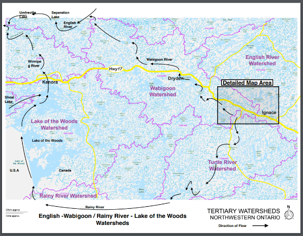
The Wabigoon River joins the English River near the community of Grassy Narrows, and together they join the Winnipeg River near the community of Wabaseemoong north of Kenora. As has been well documented, the Wabigoon River was contaminated with industrial mercury from the pulp and paper mill in Dryden over a period of five to ten years during the 1960s. The mercury-bearing fish on which Grassy Narrows depended has been the cause of Minamata disease,3 a devastating disease of the nervous system. The effects of this contamination are still being felt today.
The Turtle River flows southwest from the Revell Lake site into the Rainy River at Rainy Lake, then into Lake of the Woods before entering the Winnipeg River at Kenora. The Winnipeg River flows north through Manitoba and becomes part of the Nelson River flowing into Hudson Bay.
Conclusion
While the degree of risk of contaminants from groundwater are not well established in the absence of local hydro-geological information, it is well-known that over time there will be releases of radionuclides from the DGR to the surface environment.
In addition, based on the preliminary information released by NWMO, there is an expectation that radioactive elements will enter the surface water directly during repackaging at the surface before being deposited underground. The NWMO has been vague about the optional plan for “shallow storage” over the years, but if pursued it would present an area of additional risks. In fact, NWMO’s plans are known to change regularly as objections arise and as information becomes known. It seems counter-intuitive that a community like Ignace or Wabigoon Lake Ojibway Nation should be asked to demonstrate willingness to accept the risks associated with this project, when the project itself is still largely undefined.
~ Charles Faust
We The Nuclear Free North
18/03/2022
Footnotes
1 See for example, the article https://pubs.cnl.ca/doi/pdf/10.12943/ANR.2013.00018 . Note that it does not debate whether radionuclides will be released from a DGR, but rather compares releases from CANDU fuel to releases from reprocessed fuel.
2 Ontario Flow Assessment Tool https://www.lioapplications.lrc.gov.on.ca/OFAT/index.html?viewer=OFAT.OFAT&locale=en-ca
3 Canadian Medical Association Journal 2017 Feb 6; 189(5): E213–E215. https://www.ncbi.nlm.nih.gov/pmc/articles/PMC5289874/
Download the PDF of this article:
“What is the Risk that Surface Water will be Affected if a Deep Geological Repository for All of Canada’s High Level Nuclear Waste Proceeds?”
